1.3

Innovating for
the aeronautical sector

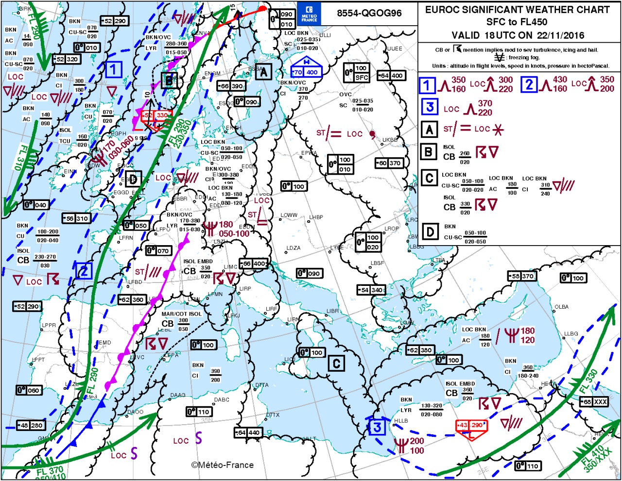
Météo-France, exclusive service provider for the French airspace

As a certified service provider and appointed by the Government for the "Single European Sky" initiative, Météo-France is responsible for delivering the meteorological service for air navigation in the French airspace.

On 1 December 2016, when the 2nd certificate expired, the Civil Aviation Safety Directorate (DSAC), the national surveillance authority for air navigation service providers, renewed Météo-France’s certification for an unlimited period of time – the first time this has ever been done.

Now allowed by European regulations, this decision was taken in light of the maturity Météo-France has reached in the services it provides for air navigation. The DSAC also maintained that it had every faith in the institution’s continued conformity and ability to correct any deviation it might observe in the years to come.

With this new certificate, the institution retains its status, for the French airspace, as the exclusive provider of meteorological services for air navigation as defined in the appointment ruling dated 20 December 2011.

A new forecast map for airlines

Exemple de carte TEMSI EUROC.
Example of the TEMSI EUROC (significant weather) chart. © Météo-France

For more than twenty years, Météo-France has been producing a significant weather chart at regular intervals for the aviation industry, covering the whole of Europe. Drawn up at the request of airlines for their short and medium-haul flights, the TEMSI EUROC chart is updated every 3 hours.

This provides the forecast with four-hourly lead times of all significant weather events for this industry, including areas of icing, storms and areas of turbulence, as well as other details useful for flight planning such as fronts, cloud cover, visibility, jet streams and freezing level.

To improve coverage even further of the medium-haul flight network, at airlines’ request Météo-France has significantly expanded the scope of the chart which, since July 2016, now includes the Near East.

Air France pilots can now access data on tablets

Tablette
New meteorological data on Air France pilots' tablets with the eWAS system. © GTD

In June 2016, Air France launched an invitation to tender to equip its pilots with an aeronautical information system incorporating meteorological data from different sources. The tenderer eventually chosen was the firm GTD, with its eWAS system developed using Météo-France datasets. All 4,000 of Air France’s pilots can now use their tablets to access Météo-France information (detection and development of convective cells, areas of icing and turbulence around the globe) which rounds off the regulatory meteorological information. To meet these needs, through 2016 Météo-France’s Space Meteorology Centre extended its product for detecting rapidly developing convective cells (RDT, Rapidly Developing Thunderstorm) worldwide. The lightning datasets of Météorage (a subsidiary of Météo-France) are also available.

Aeronautical forecasters attuned to pilots’ environment

Prévisionnistes sensibilisés

In September 2016, an initial pilot environment awareness day was organized for aeronautical forecasters at the Météopole in Toulouse. There are plans to hold this initiative again over the next three years at least, in each mainland and Overseas management so as to reach out to the institution’s 350 aeronautical forecasters. The first event gave pilot federations the opportunity to present their disciplines and discuss the developments in Météo-France’s services, one example being AÉROWEB.

A network of LiDARs for monitoring volcanic ash

Lidar aérosol installé à Aléria en Corse
Aerosol LiDAR installed in Aléria, Corsica. © Météo-France

The eruption of the Eyjafjallajokull volcano in Iceland completely disrupted air navigation across the European sky in 2010. In order to improve airspace management over the territory should there be another volcanic eruption, in 2016 Météo-France armed itself with an aerosol LiDAR network, the first to be operational in Europe. These help to locate and characterize clouds of volcanic ash and to improve predictions of their movement.

The LiDARs are installed in Aléria (Haute-Corse/Upper Corsica), Brest (Finistère), Lille (Nord), Momuy (Landes) and Trappes (Yvelines). A mobile LiDAR based in Toulouse could also be moved in a volcanic emergency, at the request of the Toulouse-based Volcanic Ash Advisory Center (VAAC) teams.

Discover the other chapters of the current part