In meteorology and climatology, international cooperation is essential both at operational level, where it facilitates access to data produced across the world, and in terms of research and development. Météo-France fully contributes to this cooperation both at European level, within the various agencies that ensure pooling and coordination of resources on a continental scale, and globally, by actively participating in initiatives led by the World Meteorological Organization (WMO).
In Europe, cooperation between national meteorological services (NMS) is structured around three entities: the European Organization for the Operation of Meteorological Satellites (EUMETSAT), the European Centre for mid-term weather forecasts, and economic interest group EUMETNET which brings together 31 NMS. The agency is also largely involved in the European Copernicus monitoring programme and monitoring of the Earth and its various ecosystems.
At global level, the majority of Météo-France’s contributions are via WMO. The agency maintains strong bilateral and multilateral relationships with its European and international counterparts.
The 6th regional seasonal forecasting forum for countries in the South West Indian Ocean
From 18th to 22nd September 2017, the Regional Directorate of Météo-France for the Indian Ocean (DIROI), ensured the technical coordination of the 6th regional forum on seasonal forecasting for the South West Indian Ocean and coastal African countries in the region, SWIOCOF - The South West Indian Ocean Climate Outlook Forum.
The forum has benefited from financial support from the World Meteorological Organization via its programme to develop climate services globally, from logistical support from the Indian Ocean Commission (IOC),and from the Seychelles Meteorological Service.
The workshop brought together representatives from the Comoros, Madagascar, Mauritius, Réunion, Seychelles, as well as South Africa, Mozambique and Tanzania, with the aim to develop a regional seasonal forecast report looking at rainfall, hurricane activity and temperatures for the 3 coming months (October to January).
The meeting was also an opportunity for participating countries to acquire new skills on seasonal forecasting methods adapted to the region and particularly to the insular nature of countries in the IOC. It also helped participating meteorologists and climatologists to communicate with potential users from business sectors sensitive to seasonal climate variations, such as agriculture, water resource monitoring, risk and natural hazard management, tourism, etc.
Share the article on
Copernicus: actively contributing to climate service development
Copernicus is Europe’s monitoring programme which also monitors the Earth and its various ecosystems. The programme aims to deliver free and operational environmental satellite data and services on a European and global level.
The six services offered by Copernicus have transformed on-site satellite data into value-added information. The services are broken down into three areas of observation (land, ocean and atmosphere) and three fields (climate, emergency and security).
Météo-France is a service provider for five of the six services offered by Copernicus, with varying degrees of implication. In 2017, the agency clearly positioned itself within the Copernicus Climate Change service (C3S), expanding its contributions to all of the service’s components.
One of the objectives of C3S is to make accessible a series of Essential Climate Variables (ECV) from past satellite observations and on-site data processing. As such, Météo-France was selected as head of the C3S ECV for surface albedo in 2017. Thanks to this involvement, the agency became a major player on the international scene for remote sensing of surface properties in the optical field, responsible for the operation of several generations of instruments between 1980 and 2022.
Copernicus also promotes the production of a multi-model seasonal forecast system to which Météo-France contributes monthly by providing results from its operational forecast model. A new version (system 6) of the agency’s seasonal forecast model was added to Copernicus in a pre-operational phase in March 2017. Initial multi-model forecast sample sets, produced on 10th of every month for a consecutive period of 6 months, will be available on the C3S platform from spring 2018.
In order to achieve a full range of climate data integrating the three timeframes ‘past’, ‘present’ and ‘future’, C3S will also develop ergonomic access to climate projections incorporating a notion of uncertainty via a near systematic, set-theoretic approach. C3S will rely on CMIP 5 simulations that have been assessed within the framework of the 5th report from the Intergovernmental Panel on Climate Change on a global scale. On a regional scale, the simulations will be complemented at a spatial resolution of 12 km via new sample sets, some of which will be produced by Météo-France using the ALADIN climate model. Enriching the spectrum of climate simulations across Europe will facilitate improved qualification of uncertainties on this scale.
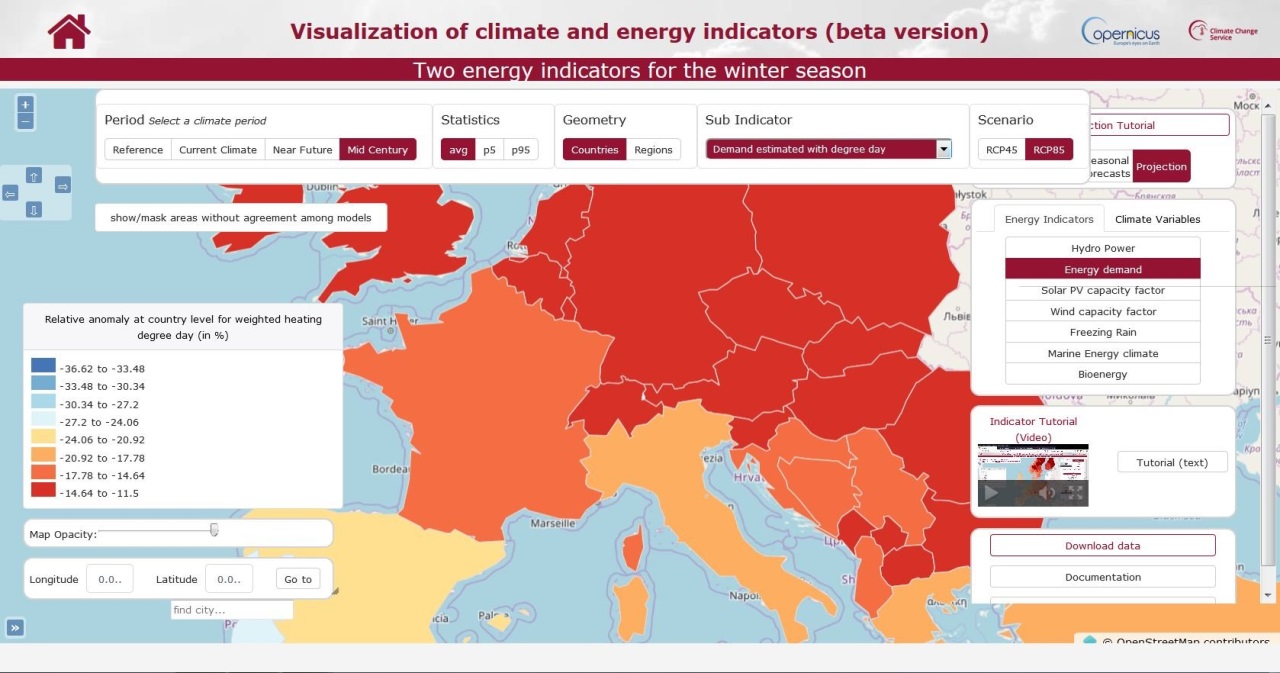
Lastly, in 2017, Météo-France delivered a demonstrator which included indicators on energy supply and demand for various timeframes: current climate, seasonal forecasts and climate projections. This tool forms part of the service offered by C3S which aims to define and produce indicators for business sectors addressed to public policies and the private sector within the context of adapting to climate change.
Share the article on
Developing climate services for the Mediterranean
The IPCC (Intergovernmental Panel on Climate Change) considers the Mediterranean to be a hot spot in terms of climate change impacts, due to the combination of extreme weather (recurrent drought, heat waves, storms, intense rainfall, storm surge) and high levels of vulnerability across the region. A number of international initiatives have been launched in recent years to improve knowledge on climate change across the Mediterranean Basin.
Seasonal forecasts are also the subject of research and development studies for sectoral applications, particularly energy, agriculture and water resource management.
As such, the Mediterranean Climate Outlook Forum (MedCOF), bringing together all weather services along the basin in Europe, the Middle East and North Africa, has been implemented under the auspices of the World Meteorological Organization. Biannual conferences take place within this framework with the objective of establishing consensual seasonal forecasts for summer and winter seasons (http://medcof.aemet.es/). The forum also aims to inform and discuss needs in terms of climate information and services that could be provided by seasonal forecasts, with public and private actors.
The MEDSCOPE project, supported by the European Union (within the framework of the JPI Climate programme) was launched in September 2017 to improve seasonal predictability in the Mediterranean and to demonstrate the potential contributions climate services could make in various economic sectors. Via its research centre and leadership of climatology and climate services, Météo-France contributes to them in order to develop diagnostics on seasonal predictability, tools adapted to downscaling, and sectoral applications based on the use of a hydrological model (SURFEX-Trip).
Since launching eight consortia responsible for SAFs (Satellite Application Facilities) within EUMETSAT, Météo-France has been fully involved in five of them as either a member or leader: numerical weather prediction (NWP SAF), nowcasting and very short range forecasting (NWC SAF), OSI SAF, (ocean and sea ice), H SAF (hydrology) and lastly LSA SAF which concerns land surface analysis.
As such, Météo-France was heavily involved in continuous improvement of the tools and development of new services in all these areas in the framework of the first two phases of the projects.
On 1st March 2017, eight consortia committed became involved in the third continuous operating and development phase, the CDOP3, which covers the period 2017-2022.
Météo-France has therefore renewed its commitment to the five SAFs for the next six years. The main challenge posed by CDOP3 is ensuring the continuity of current operational services and preparing for the arrival of MTG (geostationary) and METOP-SG (scrolling) EUMETSAT satellites. These programmes will place Europe at the forefront of weather observation by ensuring improvements in spatial, temporal and radiometric resolutions, and will provide major innovations such as the lightning imager (LI) and hyperspectral infrared sounder (IRS) by MTG.
The strategic importance of SAFs is regularly highlighted by EUMETSAT: they facilitate optimal use of facilities and resources available in Member States, capitalisation of scientific expertise and more frequent interactions between experts.
On 23rd November 1977, the 1st European geostationary satellite, Meteosat-1, was launched from Cape Canaveral in Florida. It provides images of the Earth disk (Atlantic Ocean, Europe and Africa) over three channels (visible, infrared and water vapour) every 30 minutes, that are received and processed in Darmstadt, Germany, and at the Centre for space meteorology in Lannion, France. It follows a constellation of Meteosat satellites, launched this time from the Centre spatial guyanais (Guiana Space Centre) in Kourou.
The result of collaboration between several European countries (Belgium, Denmark, France, Italy, Germany, United Kingdom, Sweden and Switzerland), the Meteosat programme monitors cloud masses over the European continent. This cooperation founded the European Organization for the Operation of Meteorological Satellites, created in 1986.
On-board instrumentation and image processing have evolved considerably since 1977. Colour composite images emerged in 1986. They provided information on the structure, thickness and altitude of clouds. Since 2002, satellites from the Meteosat Second generation programme have provided images with better spatial and temporal resolution and assist short-term snow, storm and fog forecasts. Scheduled from 2021, the 3rd generation will produce images with even greater accuracy as well as information on the atmosphere (temperature, humidity, chemistry) and lightning detection.
Share the article on
Twinning with Tunisia’s National Institute of Meteorology
The year 2017 has been a particularly rich one for twinning with the National Institute of Meteorology (INM) with 41 public expert missions and study visits benefitting 56 executives. This institutional support, which began in October 2015 for an initial period of 30 months and funded by the European Commission to the tune of €1.35m, aims to strengthen the capabilities of the Tunisian weather service.
Public expert missions, conducted in connection with beneficiaries, have covered an extremely wide area: strengthening of managerial skills and sectoral and operational steering, and team ownership of the project management approach. The role and visibility of the INM in the area of scientific research, institutional and interdepartmental exchanges were also at the heart of the twinning, with the aim to implement an Early Warning System (EWS) adapted to the concerns of the Tunisian authorities. Ultimately, preparation of the INM certification beyond the current services, solely provided to the aeronautical sector, received particular attention.
Météo-France has welcomed many foreign delegations. These visits enabled visitors in question to find out more about the agency’s expertise and infrastructure.
In this context, Lord Ed Llewellyn, British Ambassador to France since 2016, visited the Toulouse site in mainland France. This meeting enabled agency officials to present cooperation initiatives in place with the Met Office in the areas of research and operational meteorology.
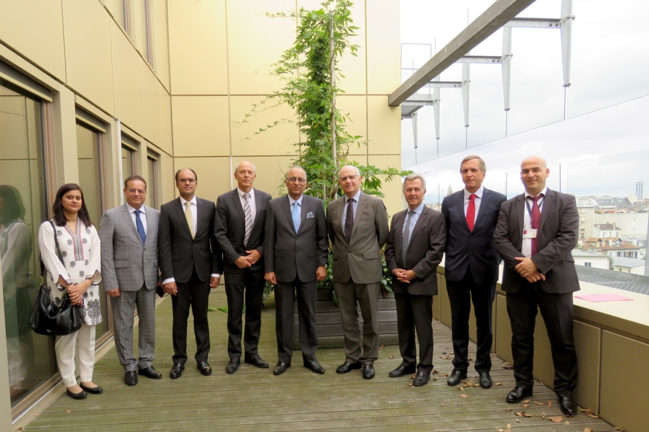
The visit of a delegation from Pakistan, led by the Pakistani Ambassador for France, Moin-ul-Haque, accompanied by the director of the Secretary for Civil Aviation, Muhammad Irfan Elahi, trustee of the Pakistan Meteorological Department (PMD), led to the signing of a Memorandum of Understanding in which the objective was to develop the competencies of the PMD. The Director of the PMD also attended the site in mainland France in order to define cooperation actions.
A delegation led by the Armenian Minister of Emergency Situations, trustee of the Armenian meteorological service, facilitated the discussion of cooperation actions that could form the subject of a potential agreement between the two services.
Directors of meteorological services in Mali, Cameroon, and a delegation led by the Deputy Executive Director of the meteorological service in Belarus were also welcomed in order to learn more about the agency’s coordination and activities and to discuss opportunities for future collaboration.
Share the article on
Training proposal aimed at an international audience
The French National School for Meteorology (ENM) offers professional training courses open to the public outside of Météo-France. A number of them, conducted in French and English, are specially designed to host interns working for foreign institutions within the field of meteorology.
Courses may cover scientific, theoretical and organizational aspects as well as operational tools and methods. In 2017, they welcomed 86 students from 33 different countries and, for the first time, specific training was offered to French-speaking meteorologists from sub-Saharan Africa with responsibility for forecast activities. The 5-day workshop, entitled ‘Meteorology in the African region’, took place in June 2017. The aim of the workshop was to consolidate and update students’ knowledge by taking into consideration the region’s meteorological specificities.
It should also be noted that a workshop taught in English ‘Workshop on WMO information System and metadata management’ took place, co-organised by Météo-France and the UK Met Office in June 2017 in Toulouse, providing training in the techniques and tools of the WIS, the World Meteorological Organization’s (WMO) new data exchange system; a training proposal intended for an international audience.
Share the article on
Naming of storms affecting Europe
Giving storms names enables more effective communication when a severe wind phenomenon is approaching. As such, a storm naming system was successfully implemented by the United Kingdom and Ireland in 2016, where surveys showed that the population was much more attentive to safety recommendations when the threat of strong winds was clearly identified as being connected to a named storm.
Météo-France have been working in partnership with Spanish (AEMET) and Portuguese (IPMA) weather services as 1st December 2017 in order to name storms likely to pass through France, Spain or Portugal. When a depression risks generating an orange level wind warning or higher in any one of these three countries, the meteorological service due to issue the first warning picks a name for the storm from a pre-established list. The depression that generates the storm therefore retains its name throughout its full life cycle.
When a storm first affects Ireland or Great Britain, the name chosen by their respective weather services is the one which will be retained, and vice versa. An extension of this coordination is underway across all European countries.