1.3

Aerospace: predicting
meteorological hazards

Weather in the cockpit

Visualisation des turbulences par le système eWas.
Visualisation of turbulence using the eWas system developed by Spanish company GTD using data from Météo-France. © GTD

Météo-France and Spanish company GTD have taken part in a number of European aerospace research programmes since 2004 (Flysafe, Alicia). These exploratory studies show that it was now possible to provide near real-time weather data to pilots in the cockpit itself.

Additionally, from 2013 onwards, both bodies positioned their work towards the operational transition of an on-board embedded weather solution available on tablets, known as the Electronic Flight Bag (EFB).

Discussions with a major airline meant pilot needs could be better identified.

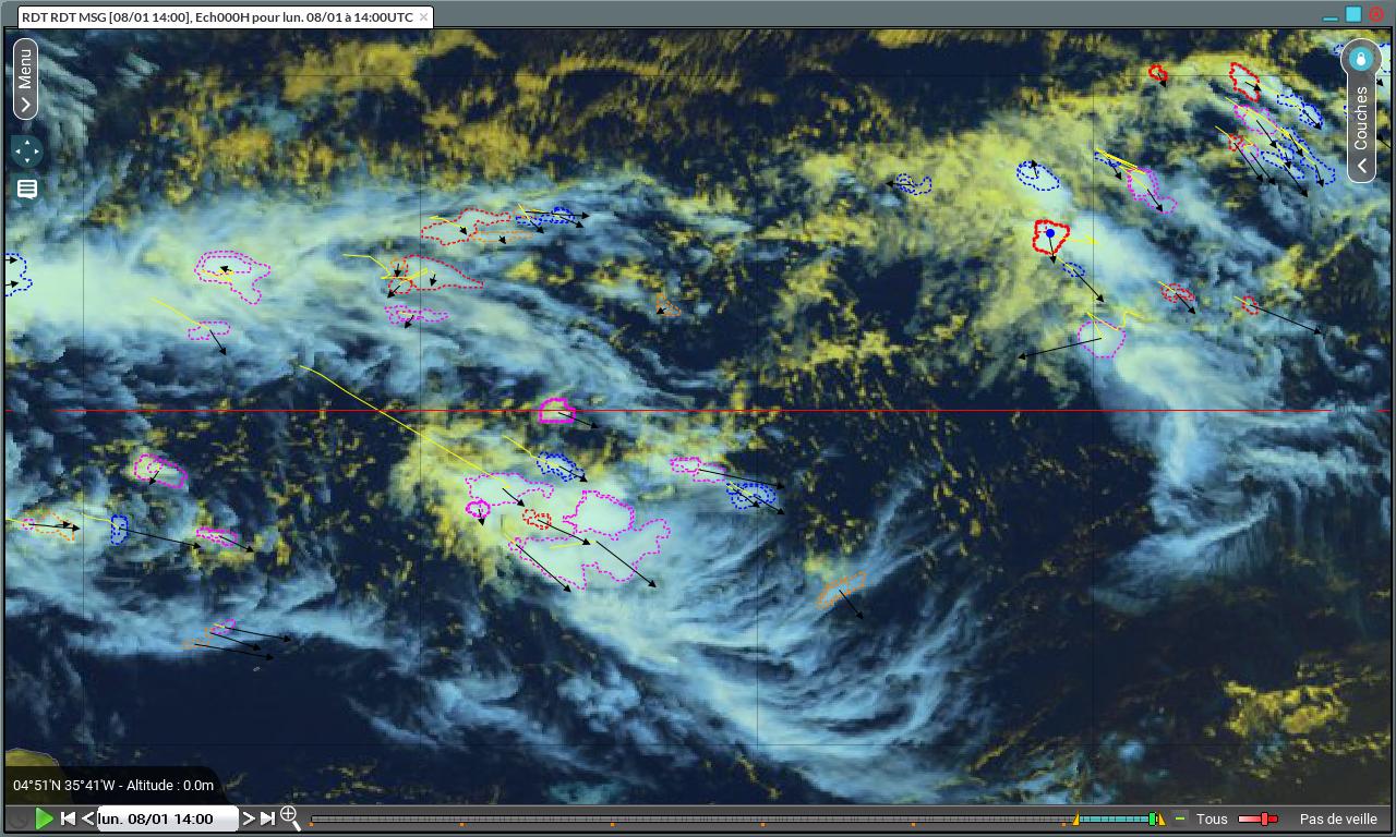
In terms of storm forecasting, Météo-France developed a comprehensive observation and forecasting service for convective cells, the Global RDT (Rapid Developing Thunderstorm), which is therefore particularly appreciated by pilots.

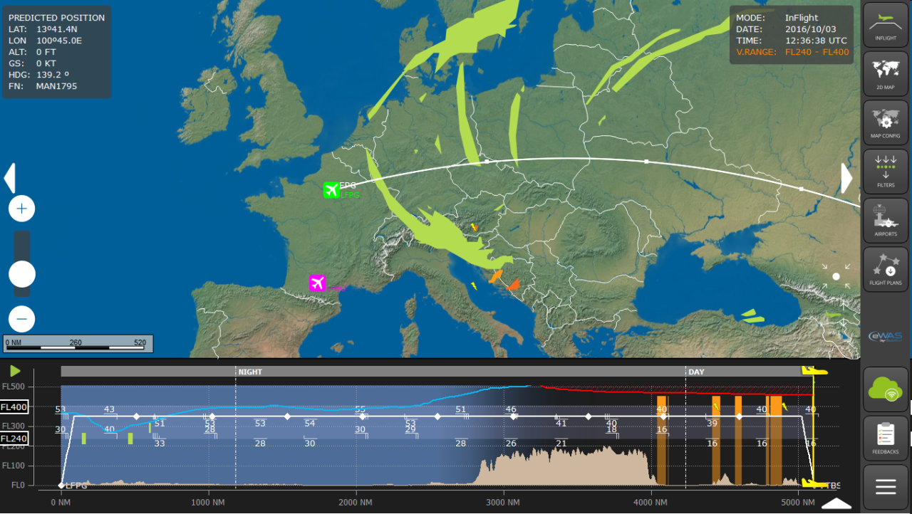
Forecasting of turbulence, frost formation and winds aloft can be provided and updated regularly thanks to various algorithms based on the comprehensive ARPEGE model developed by Météo-France.

As such, all of these weather services are provided to pilots in near real-time via an ergonomic interface developed by GTD, accessible directly on touch tablets for more efficient flight planning. Increased connectivity on certain aircraft also facilitates access to this data during flights, notably during long-haul flights.

Modernisation of telecommunications network in civil aviation

In 2017, International Civil Aviation Organization (ICAO) launched a major project to modernise its telecommunications network.

Based on technologies similar to the sending of e-mails online, the new AMHS (Aeronautical Message Handling System) protocol enables substantially higher transfer speeds to be reached and the prospective exchange of any type of document.

Changing technology and the increasing speed of these links will enable civil aviation messages to transition towards a new format, referred to as AIXM (Aeronautical Information eXchange Model). This format will enable better integration of messages within new automatic processing chains.

It has been extended by the WMO (World Meteorological Organization) for messages related to observation and forecasting (METAR, TAF, SIGMET, etc.) towards a geographical standard specific to meteorology known as IWXXM (ICAO Meteorological Information Exchange Model).

Operational since summer 2017 using Météo-France’s Transmet telecommunications system, this new AMHS connection will enable the agency’s centre in Toulouse to continue to carry out its functions as a regional operational meteorological data centre for the aerospace sector (OPMET), alongside its centres in London and Vienna.

In 2017, machine translation of these messages was implemented on Transmet in order to meet Météo-France’s international obligations. The agency’s various tools to consume or produce OPMET messages should transition to this new format in the longer term.

Data will be made available for air aviation users on the future SWIM (System Wide Information Management) network in 2025 via the MetGate gateway, of which SESAR DM development (Single European Sky Air traffic Management Research Deployment Manager) is led by Météo-France.

Alongside distribution of the regulatory messages mentioned, the gateway will enable airlines to access useful information helping them to optimise trajectories and flight safety and select the most suitable data source, between the various National Meteorological Services (NMS) available.

Storm nowcasting in commercial aviation

Identification, caractérisation et trajectoires des zones convectives par le Global RDT.
Identification, characterisation (contour colours) and trajectories of convective areas by Global RTD. © Météo-France

Storm risk detection and prediction is one of the key components of assistance provided to the aeronautical sector by Météo-France. In connection with the development of its commercial offering and with a view to covering global needs, the agency has implemented a 1-hour identification and extrapolation service for storm risk based primarily on satellite information and lightning detection networks; the Global RDT (Rapid Developing Thunderstorm). Characteristics are attributed to each storm cell: top height, mature stage, trajectory, etc.

Initial data from five geostationary satellites covering the globe reach the Centre for space meteorology (Lannion, France) either via the EUMETCast dissemination system (European Meteosat satellite and American GOES-East satellite, pending a direct reception system of the latter in 2018), or via land (GOES-West and Japanese satellite Himawari-8). Operational production then takes place partly in Lannion and partly in Toulouse, at speeds of 15 to 30 minutes depending on the satellites.

The developed product is then distributed in a synthetic object file which is light enough to be transmitted to aircraft in flight.

Discover the other chapters of the current part

1.4 Météo-France, leader of climate and meteorological services